Agriculture Drone Services
On-site Drone Mapping & Detailed Analytics: Comprehensive Insights for Your Crops and Cattle
Crop Managment


We provide insights on crop performance applying predictive analytics
Forestry Managment
Monitor forest health, track growth, and detect issues early with high-resolution drone imagery for smarter, sustainable management.
Flex Support
Tailored Solutions for Farmers and land managers so No ask will ever be too big or too small
Boost Crop Yields, Input Efficiency, and Field Health with Precision Drone Mapping
Turning multispectral drone data into clear decisions on irrigation, inputs, and field health—faster and more accurately than ever.
FieldView Essential
We offer actionable insights into crop performance by leveraging predictive analytics to identify growth trends, potential issues, and areas for optimization, empowering farmers to make informed, data-driven decisions for better yield management.
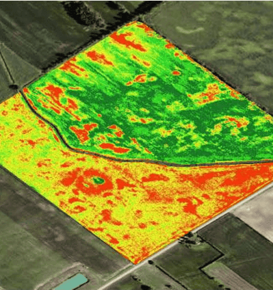
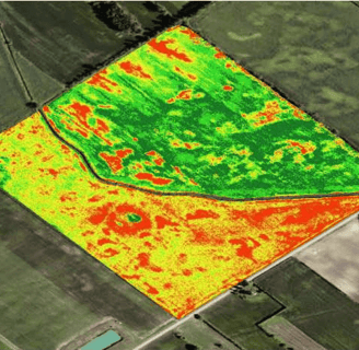
Description: This service goes beyond the basics to offer a more detailed analysis of crop health using advanced NDVI mapping and field variability assessments. With a more thorough scan of crop conditions, it allows farmers to pinpoint variations within their fields, helping to optimize resource allocation. Ideal for farmers who want actionable insights on areas that may need specific intervention or management.
Includes: High-resolution multispectral images, NDVI mapping, stitched orthomosaic field analysis.
Benefits: Detailed mapping of crop health and variability, helps identify areas for input adjustments.
Best for: Farmers with larger fields who want to monitor growth patterns and manage resources efficiently.
FieldView Precision
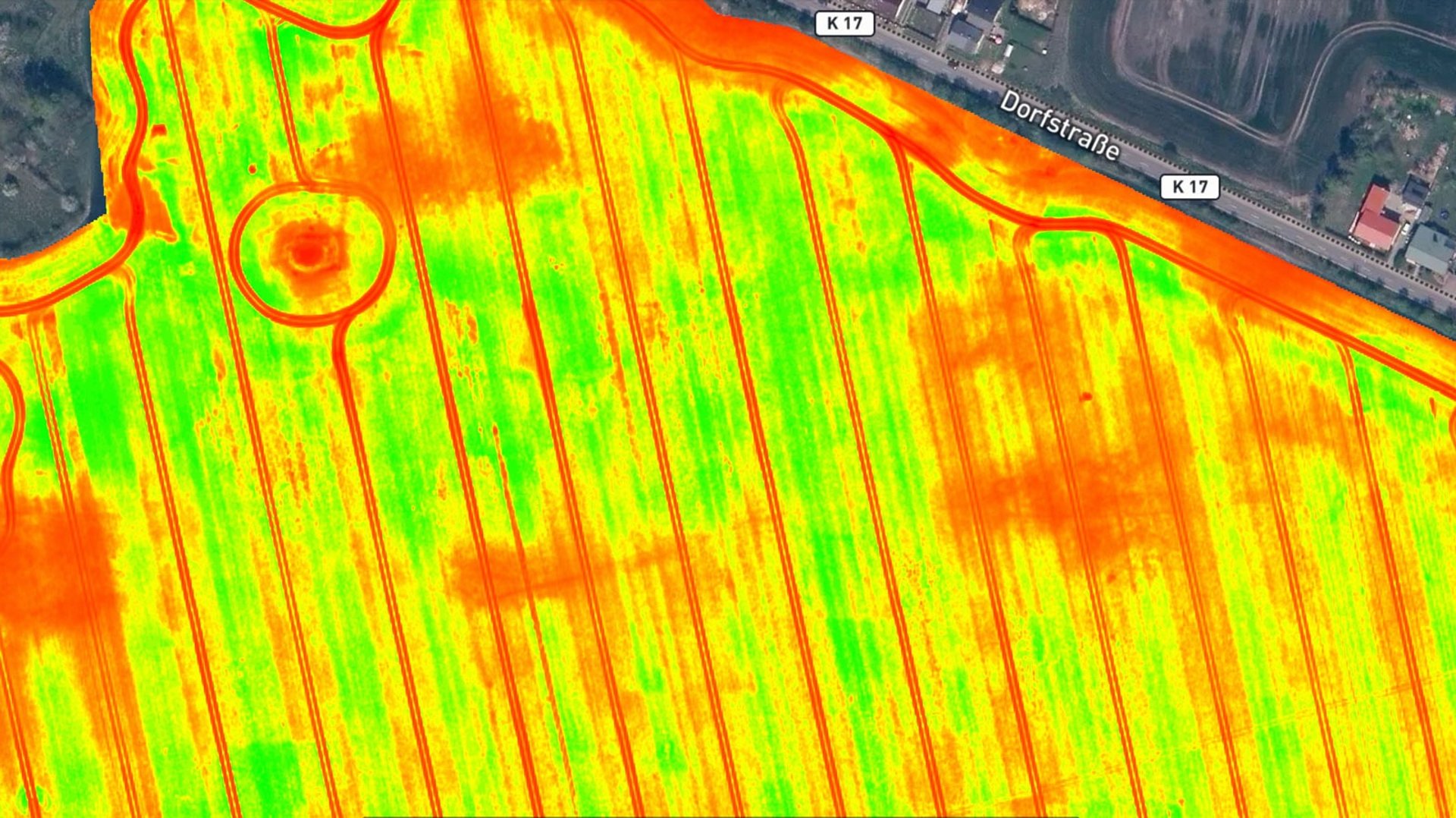
Description: Designed for those who want the most comprehensive and actionable crop insights, this service combines detailed multispectral analysis with enhanced imaging technology. It provides a deeper dive into crop stress, emerging diseases, and growth patterns, allowing farmers to make data-driven decisions for precision agriculture. Stand counts and more nuanced field variability mapping are included to ensure optimal crop performance and resource use.
Includes: Advanced multispectral analysis, crop stress identification, stand count evaluations, detailed field variability maps.
Benefits: Identifies stress early for better management decisions, helps with accurate crop yield prediction, and provides insights for Variable Rate Application (VRA) planning.
Best for: Farmers focused on precision agriculture practices, aiming to maximize input efficiency and yield potential.


Maximize Forest Health, Yield, and Sustainability with Aerial Mapping
Harness drone data to optimize timber harvests, assess forest vitality, and make informed land management decisions.
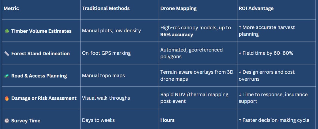
Better Forest Data = Smarter Forestry Decisions
Drone-based forestry mapping delivers detailed, actionable insights that save time, reduce costs, and maximize timber value.

Precision Forest Intelligence at Your Fingertips
What we can Deliver with Multispectral Mapping
🌳 Pre-Harvest Planning Map the healthiest timber zones and avoid waste
🌱 Reforestation Monitoring Measure growth rates, survival, and coverage
🔥 Post-Fire Recovery Assess damage and plan restoration
🛣️ Road and Skid Trail Mapping Elevation-aware routing with terrain modeling
🧭 Conservation Monitoring Map habitat zones, canopy cover, and forest edge dynamics
We help you manage your forest like the long-term asset it is—with real-time insights, not guesswork
Flex Support
A versatile, on-demand aerial support service designed to assist farmers with field operations, environmental monitoring, and farm logistics. Whether it’s assessing infrastructure, tracking equipment, or evaluating storm damage, Flex Support provides quick, actionable insights without a full-scale mapping service.
Weather & Environmental Assessments
Wind Damage & Weather Impact Assessments – Evaluate storm damage from high winds, hail, or flooding.
Weed Infestation Mapping – Locate and quantify problem areas for targeted herbicide application.
Harvest & Field Operations Support
Harvest Progress Documentation – Capture aerial images and videos for tracking efficiency and logistics.
Equipment & Vehicle Tracking – Monitor farm machinery locations and movement for operational oversight.
Water & Irrigation Management
Irrigation System Inspection – Detect leaks, pressure drops, or malfunctions in irrigation pivots.
Drainage & Water Flow Analysis – Identify areas of poor runoff, standing water, or erosion risks.
Fence & Property Line Inspections – Identify damage or breaches along farm boundaries.
Greenhouse & Facility Inspections – Check for structural integrity, ventilation issues, or material wear.